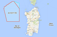
Geophysical survey within the offshore prospecting permit "d 2 E.P-.TG" located off the north-west coast of Sardinia, marine area "E"
General information
Work: Hydrocarbons prospecting permit "d 2 E.P-.TG"
Project: Geophysical survey within the offshore prospecting permit "d 2 E.P-.TG" located off the north-west coast of Sardinia, marine area "E"
Description: The project involves the acquisition of 7818 km of 2D seismic lines and the subsequent acquisition of data through 3D geophysical survey extending over an area of about 6000 km2 in the Sardinian Sea, marine Zone E
Developer: TGS - NOPEC
Project type: Hydrocarbons prospecting
Related website: Ministero dello Sviluppo Economico
Deadline for submission of comments: 27/09/2016
mail
Territories and marine areas

Regions: Sardegna
Provinces: Sassari, Oristano
Municipalities: Stintino, Oristano, Bosa, Tresnuraghes, Olbia, Cuglieri, Alghero, Porto Torres, Sassari, Narbolia, San Vero Milis, Villanova Monteleone, Magomadas
Marine areas: Mar di Sardegna
Select procedure
| Procedure |
Procedure Code |
Starting date |
Stage of the procedure |
|
|
| Environmental Impact Assessment |
2947 |
05/02/2015 |
Concluded |
Procedure details
|
Documents
|
| Procedure Code (ID_VIP/ID_MATTM) |
2947 |
| Date of application submission: |
05/02/2015 |
| Publication date of the notice in newspapers: |
02/02/2015 |
| Deadline of submission of Public Comments: |
06/04/2015 |
| Technical assessment starting date: |
09/02/2015 |
| Date of request for integrations: |
10/08/2015 |
| Republication date of the notice in newspapers: |
22/07/2016 |
| Deadline of submission of Public Comments on the republished project: |
27/09/2016 |
| Republication subject
: |
Integrazioni pervenute in data 25/07/2016 |
| Date of the Opinion of the National Technical Commission : |
13/01/2017 |
| National Technical Commission Opinion number: |
2274 |
| National Technical Commission Opinion outcome: |
Negativo |
| Date of the EIA Decree: |
14/07/2017 |
| EIA Decree number: |
DM-0000183 |
| EIA Decree outcome: |
Negativo |
| Notes: |
Con nota del 29/10/2015 (prot. DVA-2015-0027108) è stata concessa una proroga di 60 giorni per la consegna delle integrazioni (data consegna integrazioni 24/11/2015). Con nota del 14/03/2016 (prot. DVA-2016-0006961) è stata concessa una proroga di 8 mesi per la consegna delle integrazioni a partire dal 24/11/2015. |
| Responsible of the procedure: |
Carmela Bilanzone - tel. 0657225071 - 0657225070 - va-5@mite.gov.it |
| Stage of the Procedure: |
Concluded |
